(Dan Tri) – In an effort to monitor China’s illegal reclamation and militarization of the East Sea, Reuters journalists in cooperation with a company specializing in analyzing satellite images studied hundreds of photos and reported them.
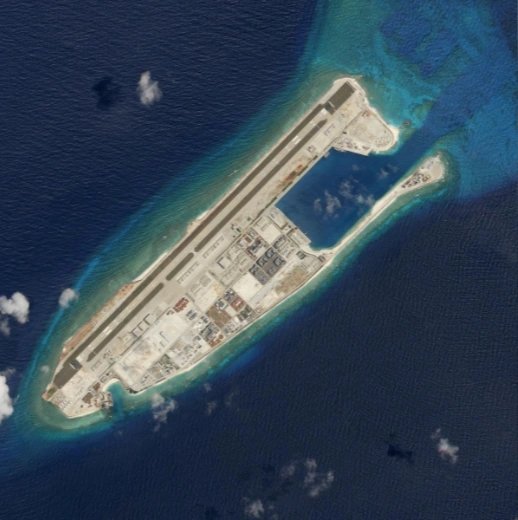
Satellite photo of Fiery Cross Rock on March 19 (Photo: Reuters)
For a long time now, China’s silent construction of artificial islands, illegal construction and deployment of military assets to reefs in Vietnam’s Truong Sa archipelago has always been a matter of concern and concern to world public opinion.
Mr. Simon Scarr, deputy director of graphics at Reuters news agency working in Singapore, has long worked with private satellite image providers to analyze the situation in the East Sea.
Late last year, when speaking with Earthrise Media, an independent group that helps journalists collect and analyze satellite data, Mr. Scarr wondered whether Earthrise could count the projects built by China.
After 6 weeks of research, Earthrise released hundreds of satellite photos from 2014 onwards since China began accelerating the process of building illegal artificial islands.
In a document containing data confirming China’s illegal construction in the East Sea, a number has attracted the attention of world public opinion.
In addition, these data can also show China’s ambition to expand and militarize the East Sea, even though they previously claimed that the structures were built for civilian purposes.
From the data obtained, Mr. Scarr and his colleagues have built a database of China’s wrong activities in the East Sea along with images and information from diverse sources to serve their activities.
According to Reuters, on Subi Reef, Mischief Reef and Fiery Cross Reef, China illegally built similar facilities including a missile platform area, a 3 km long runway, and a warehouse area.
Lord Emperor


